
United States News
See other United States News Articles
Title: Florida Panhandle Bracing for Category 4 Hit from Michael
Source:
WU
URL Source: https://www.wunderground.com/cat6/F ... tential-Category-4-Hit-Michael
Published: Oct 10, 2018
Author: Bob Henson
Post Date: 2018-10-10 06:07:59 by IbJensen
Keywords: None
Views: 212
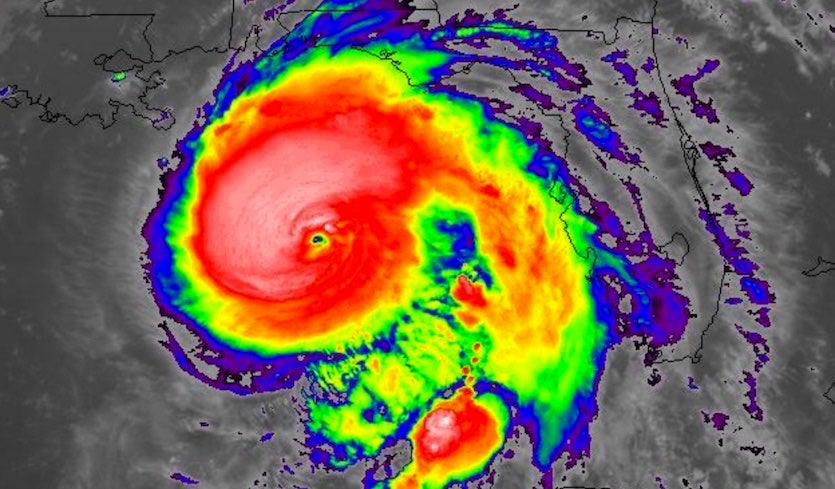
(Above: Infrared satellite image of Hurricane Michael at 0212Z Wednesday, October 10, 2018 (11:23 pm EDT Tuesday). Image credit: NASA/MSFC Earth Science Branch.) Just hours away from an expected Wednesday afternoon landfall, Hurricane Michael became ever stronger and more organized on Tuesday night over the eastern Gulf of Mexico. Michael’s high winds, torrential rain, and very large storm surge were pushing briskly toward the Florida Panhandle and the Big Bend region just to the east, the areas in line to experience the worst impacts. Update (2 am EDT Wednesday): Michael has been upgraded to Category 4 strength as of 2 am EDT, with top sustained winds of 130 mph. Some additional strengthening is possible before landfall. Satellite images of Michael’s evolution on Tuesday night were, in a word, jaw- dropping. A massive blister of thunderstorms (convection) erupted and wrapped around the storm’s eye, which has taken taking a surprisingly long time to solidify. A layer of dry air several miles above the surface being pulled into Michael from the west may have been one of the factors that kept Michael from sustaining a classic, fully closed eyewall (see embedded tweet below). A closed eyewall is normally a prerequisite for a hurricane to intensify robustly, but somehow Michael managed to reach Category 3 status without one. Based purely on the Dvorak method, which uses cloud-top temperatures from satellites to estimate hurricane strength, Michael was a Category 4 storm by Tuesday evening. Michael’s central pressure dropped from 965 mb at 1 pm EDT to 947 mb at 11 pm, another sign of robust strengthening. However, it can take a few hours for a hurricane’s winds to fully respond to changes in the inner core’s structure and pressure. A hurricane-hunter mission found flight-level winds of 130 knots (150 mph) and radiometer-estimated surface winds of 110 knots (127 mph) just after 8 pm EDT. In its 11 pm EDT advisory, the National Hurricane Center pegged Michael's top sustained winds at 125 mph, just shy of Category 4 status. Assuming that Michael maintains or improves its structure overnight, these winds are likely to increase in response, and NHC is now predicting that Michael will approach the coast as a Category 4 hurricane on Wednesday morning. If Michael reaches the coast with top winds of at least 130 mph (minimal Category 4 strength), it will be the strongest hurricane landfall ever recorded in the Florida Panhandle, as well as along most of Florida's Gulf Coast—all the way from the Alabama border to Punta Gorda—in records going back to 1851. Models trending stronger with Michael The 18Z Tuesday run of our top intensity model from 2017, the HWRF model, predicted that Michael would peak as a Category 4 storm with 145 mph winds at 8 am EDT Wednesday, then weaken to a high-end Category 3 with 125 mph winds at landfall, early Wednesday afternoon. The 18Z Tuesday run of the HMON model predicted Michael would peak as a Category 4 storm with 150 mph winds at 8 am Wednesday, then weaken by landfall to a Category 4 hurricane with 140 mph winds. The latest 0Z Wednesday runs of our other two top intensity models, DSHIPS and LGEM, predicted that Michael would make landfall as a borderline Category 3 or 4 hurricane with 125 – 130 mph winds. Landfalling Category 4 hurricanes are rare in the mainland U.S., with just 24 such landfalls since 1851—an average of one every seven years. (Category 5 landfalls are rarer still, with just three on record). Our two most reliable rapid intensity forecasting models, SHIPS and DTOPS, predicted with their 0Z Wednesday forecasts that Michael had a 20% and 0% chance, respectively, of becoming a Category 5 hurricane with 160 mph winds before landfall. SHIPS is the model NHC uses operationally to forecast rapid intensification, and DTOPS is an experimental model that NHC started evaluating last year. One of the most at-risk locations for a high storm surge is Apalachicola, FL. Storm surge expert Dr. Hal Needham’s U-SURGE project has a web page dedicated to the storm surge history there. In an email, Dr. Needham explained that the page allows us to compare Michael's surge with high water marks from 40 other hurricanes and tropical storms. When sea level rise is removed, an Unnamed Hurricane (1903) and Hurricane Elena (1985) both produced water levels 10 feet above the annual mean sea level. Michael's storm surge will be comparable, or possibly exceed these levels, depending on the track. Apalachee Bay, where NHC is predicting the highest storm surge from Michael—up to 13 feet—generates storm surge very efficiently because of its concave shape and shallow bathymetry. East-facing shores along Apalachee Bay in places like Apalachicola and Carribelle are generally more vulnerable than west-facing shores closer to where Michael is expected to make landfall, like Mexico Beach, because east-facing shores observe prolonged onshore winds as the hurricane approaches from the south. West-facing coastlines, however, observe a prolonged offshore wind, followed by an onshore wind that suddenly strikes after the center passes. The rapid change of wind direction does not enable storm surge to build up as efficiently. This explains why east-facing Shell Beach, in eastern Louisiana near New Orleans, observed a higher storm surge (7.51’) than Morgan City (Amerada Pass) in central Louisiana (7.06’), from Texas-landfalling Hurricane Ike. Morgan City was approximately 85 miles closer to Ike's landfall than Shell Beach, but the west-facing shore limited Ike's storm surge potential in that small area. Michael’s track beyond the Gulf Coast Landfall will be only the start of Michael’s expected multi-state rampage. As it accelerates to the northeast, Michael will bring tropical-storm-force winds further inland than usual for a landfalling hurricane. These will be capable of downing trees and power lines in deadly fashion across a vast swath of southern Georgia into South Carolina and even North Carolina. Power outages could affect many hundreds of thousands of people, and the huge, simultaneous toll on the power grid indicates that some of those outages will not be repaired for days. Intensity models agree in projecting Michael to remain a tropical storm all the way to the coast of North Carolina and Virginia, where it will pop back offshore late Thursday or early Friday. Rains of 4” – 8” (locally higher) along and near Michael’s path may trigger flash floods, especially where soil is saturated in the wake of Hurricane Florence and other rains of recent weeks. Rivers have receded well below flood stage, so widespread river flooding is not expected. Michael may lash the NC/VA coasts with a parting shot of high wind on Friday as it reintensifies offshore, en route to becoming a powerful post-tropical storm over the open Atlantic.
Poster Comment: types of damage we may see see from Michael: Becoming a Cat 5 Catastrophic storm surge damage. Total destruction of mobile homes. Roof failure of all Pre-Andrew homes and businesses Peeling of roofs for many post-Andrew homes and businesses Failure and possible disintegration of gas awnings and metal roofs, especially pre-Andrew ones if there are any that old. Virtually all trees blown down in the eye wall in the right front quadrant
Dr. Rick Knabb ✔ @DrRickKnabb This isn’t going to be like past western FL panhandle/AL majors like Dennis, Ivan, Opal, Eloise. And it’s not like Hermine, Kate farther east but weaker. #Michael will make new history for central Panhandle, Big Bend. Some of you could get water and wind worse than ever before.
Michael has been adhering closely to the general course predicted by our top track models. With steering currents solidly in place, there is no reason to expect Michael to greatly depart from a northward track that will start to bend to the north-northeast around or just before landfall. Model guidance is clustered tightly near the center of the NHC forecast cone. Landfall is most likely between Pensacola and Apalachicola early Wednesday afternoon. Note that the hurricane warning for Michael includes the entire Florida coast from the Alabama border to Suwanee River, in part because of the small remaining track uncertainty but also because Michael’s wind and surge impacts will extend well east of its center.
Post Comment Private Reply Ignore Thread
[Home] [Headlines] [Latest Articles] [Latest Comments] [Post] [Mail] [Sign-in] [Setup] [Help] [Register]