International News
See other International News Articles
Title: Mcgowanjm Wire 2012
Source:
[None]
URL Source: [None]
Published: Feb 26, 2012
Author: Various
Post Date: 2012-02-26 09:15:13 by A K A Stone
Keywords: None
Views: 1641023
Comments: 2390
Mcgowinjm Wire Service.
Post Comment Private Reply Ignore Thread
Top • Page Up • Full Thread • Page Down • Bottom/Latest
Begin Trace Mode for Comment # 1459.
#1445. To: A K A Stone, All (#0)
Re: World Markets - URL Post Wed Jun 27, 2012 9:25 am by mcgowanjm Start watching for news of: Fram and Davis Straits Greenland and Ocean Heat Flux: * Arctic sea ice shrinks to lowest June extent ever observed - Alaska Dispatch * Atlantic Heat Constrains Arctic Sea Ice Extent - Science Daily (press release) * Arctic sea ice enters its final decline (2) - Record-Searchlight (blog)
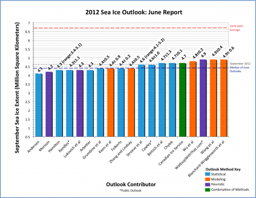
ARCUS June Sea Ice Outlook – The ‘New Normal’ Posted on June 21, 2012 by Anthony Watts From ARCUS: I’m late getting this posted, apologies. WUWT comes in third highest, same position we were last year. My thanks to Helen Wiggins for allowing us to enter again this year. – Anthony With 19 responses for the Pan-Arctic Outlook (plus 6 regional Outlook contributions), the June Sea Ice Outlook projects a September 2012 arctic sea extent median value of 4.4 million square kilometers, with quartiles of 4.3 and 4.7 million square kilometers (Figure 1). This compares to observed September values of 4.6 in 2011, 4.9 in 2010, and 5.4 in 2009. Both the 2012 quartile values and the range (4.1 to 4.9) are quite narrow. The 2012 June Outlook differs from all previous Outlooks in that there are no projections of extent greater than 5.0. It is always important to note for context that all 2012 estimates are well below the 1979–2007 September mean of 6.7 million square kilometers. Figure 1. Distribution of individual Pan-Arctic Outlook values (June Report) for September 2012 sea ice extent. Download High Resolution Version of Figure 1. Individual responses are based on a range of methods: statistical, numerical models, comparison with previous rates of sea ice loss, composites of several approaches, estimates based on various non-sea ice datasets and trends, and subjective information. The consensus is for a continued downward trend of September sea ice. It seems that the time may have come to declare that the arctic sea ice has in fact reached a “New Normal.” The physical justification for this statement is based primarily on the loss of old, thick sea ice and the increased mobility of sea ice. An expanded discussion of sea ice age and thickness is included in this month’s full report, which includes new sea ice thickness data from NASA “IceBridge” aircraft flights in March–April 2012. Credit for Sea Ice Outlook Report: Arctic Research Consortium of the US (ARCUS) The Sea Ice Outlook is organized by the Study of Environmental Arctic Change (SEARCH) and the Arctic Research Consortium of the U.S. (ARCUS), with volunteer efforts of Outlook contributors. Funding is provided by the National Science Foundation (NSF) and the National Oceanic and Atmospheric Administration (NOAA).
Don't know why that comforts you. Here's a better way to look at it.... Melt Accelerating. So by September you're looking at a plus 1600 GigaTon melt.
So by September you're looking at... No sh*t!! Really? Ice melts over the summer in the Northern hemisphere?? Wow....
#1465. To: Liberator (#1459)
That's Mister Jimmie to you, and you're not reading. Kinda like you Fundy's aren't thinkin'.....;} "(1596), though since these were often surrounded by pack-ice their northern limits were not so clear. " See, Libby, here's the problem. Human Civilization Only exists in the last 12 000 years, 6000 if you're a Fundy. And the ONLY thing Human Civilization has known in those 12 000 years is....wait for it.... the Arctic is ALWAYS covered in thick PERM ICE.... NewNews: www.eurekalert.org/pub_re...012-06/uoma-acm061512.php "In order to quantify the climate differences associated with the variable interglacial intensities, four warm phases were investigated in detail: the two youngest, "normal" interglacials, (ATTN FUNDY'S:) **************** since 12,000 years ***************** and about 125,000 years ago, and two of the "super" interglacials, about 400,000 and about 1.1 million years ago. According to pollen-based climate reconstructions, summer temperatures and annual precipitation during the super interglacials ***********were about 4 to 5 degrees C warmer*************** (Where we'll be in 15 years;) and about 12 inches (300 mm) wetter than during normal interglacials. The super interglacial climates suggest that it's virtually impossible for the Greenland's ice sheet to have existed in its present form at those times. Simulations using a state-of-the-art climate model show that the high temperature and precipitation during the super interglacials cannot be explained by Earth´s orbital parameters or variations in atmospheric greenhouse gases alone, which geologists typically see driving the glacial/interglacial pattern during ice ages. This suggests additional climate feedbacks are at work. The scientists suspect the trigger for intense interglacials might be in Antarctica. Earlier work by the international ANDRILL program discovered recurring intervals when the West Antarctic Ice Sheet melted. The current study shows that some of these events match remarkably well with the super interglacials in the Arctic."
Top • Page Up • Full Thread • Page Down • Bottom/Latest
#1447. To: mcgowanjm (#1445)
#1454. To: SJN (#1447)

#1459. To: mcgowanjm (#1454)
Melt Accelerating.
Replies to Comment # 1459. (1596), though since these were often surrounded by pack-ice their northern limits were not so clear.
End Trace Mode for Comment # 1459.
[Home] [Headlines] [Latest Articles] [Latest Comments] [Post] [Mail] [Sign-in] [Setup] [Help] [Register]

